The hawkwatch is located at the western edge of Bedford County and the eastern edge of Somerset County (Shade Township) on the Allegheny Front, north of Rt30 (north of where the old Ship Hotel or Noah's Ark use to be). The county line passes near the hawkwatch, just west of the Front. The Allegheny Front is a prominent scarp (500+ ft) that is the eastern edge of the Allegheny Plateau, at an elevation of 2780+ feet. To the east is the Valley and Ridge physiographic province of Pennsylvania. The Allegheny Front is also an eastern continental divide; to the east is the Susquehanna River drainage to Chesapeake Bay; to the west is the Ohio River drainage to the Mississippi River and Gulf of Mexico. The valley east of the hawk watch drops to an elevation of about 1240- ft along the streams. Shawnee Lake, visible to the south of the hawk watch, has a surface elevation of 1170~ ft. The topographical relief of the region is roughly 1600~ ft.
Driving directions to Allegheny Front Hawk Watch:
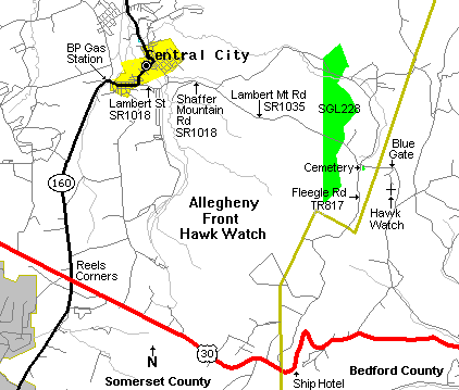
From Rt30 at Reels Corners take Rt160 (Rock Cut Rd) north 4 miles to Central City. At Rt30 a road sign points north to Windber, not Central City. Reels Corners is toward the eastern end of Long View, a four to five mile straight stretch of Rt30, near Indian Lake Christian Center.
Entering Central City Rt160 makes a sharp right at a BP Gas Station. At the next bend, where Rt160N makes a sharp left, instead go straight onto LAMBERT ST (SR1018). Go SLOW - watch out for a **ROUGH** railroad crossing. After the railroad crossing bear to the right to stay on LAMBERT ST.
LAMBERT ST becomes SHAFFER MOUNTAIN RD (SR1018) outside Central City.
1.4 mile out of Central City bear right at a Y intersection onto LAMBERT MT RD (SR1035).
On LAMBERT MT RD go 2.9 mile, thru State Game Lands (SGL) 228, to a small 4-way intersection (Daley on topo maps) where LAMBERT MT RD intersects FLEEGLE RD (TR817). Go straight thru the intersection, staying on LAMBERT MT RD, which becomes a gravel & dirt road. Daley Cemetery is on the right. Go 0.5 mile to a blue gate on the right. Turn right at the blue gate & go 0.3 mile to the hawk watch parking area, do not park along this narrow one-lane road. There are aluminum falcon symbols along either side of this dirt road. If the gate is closed find a place to park near the gate, & walk the 0.3 mile to the hawkwatch. This dirt road from the blue gate ends at the hawkwatch.
The hawk watch is 9 miles from Rt30 via the above route through Central City.
FLEEGLE RD (TR817), 4.5 mile from the cemetery to Rt30, is a rough, windy, rocky, narrow dirt road that meets Rt30 just west of the old Ship Hotel (burned to the ground in Oct. 2001), on a step of the ridge. Use Fleegle Road if you are game for a rough ride, though it is not as rough as it use to be due to development.
Some of the best days for seeing migrating hawks at Allegheny Front can be with the wind out of the east; when a high pressure system is to the north and/or a low pressure system is to the south. Good winds at the Front are in the southwest quadrant of a high pressure system, and the northeast quadrant of a low pressure system. Low cloud cover, but not so low that it fogs the Front, keeps the hawks flying lower making for closer flight paths for viewing. A mix of sun and clouds and a breeze or wind out of the east is good. The sun generates thermals over the fields in the valley; the east wind creates an updraft over the front; the clouds keep the hawks from flying too high. Another good time, though rare, to be at the Front is in late summer or autumn the day after the remnants of a hurricane or tropical depression passes over Pennsylvania from the south or mid-Atlantic coast. Large low pressure systems from the south or mid-atlantic block the southward movement of migrating birds. The migrants pause and their numbers build north of the system, waiting for the system to pass. Once the system passes to the north/northeast the stalled migrants surge southward in larger than usual numbers. It can be dramatic. September 20 2003, after the remnants of hurricane Isabel passed western PA (landfall was in NC), 833 hawks were counted passing the Front. In September of 1999 Tropical Depression Dennis (Aug. 28 to Sept. 6) and the remnants of Hurricane Floyd (Sept. 14 to 18) effected the state. On Sept. 19, in the aftermath of Floyd, some 658 hawks were seen passing the Front.
On September 12, 2004 a total of 3,031 raptors (9 species) were counted flying by Allegheny Front; 2,986 were Broad-winged Hawk. A single kettle of Broad-winged Hawks was estimated at 500.
Allegheny Front Hawk Watch gets a good number of Golden Eagles that pass southward in November & early December. On November 23 2003, 51 Golden Eagles were observed passing the front on their way south, exceeding what had been a single day record of 33. Three days prior to this, on November 20 2003, 51 Golden Eagles were observed passing the Franklin Mountain Hawkwatch 350~ miles to the northeast in southcentral New York state. On Monday, November 14 2005, 45 Golden Eagles were observed passing the Alleghent Front Hawk Watch. Forty of the eagles passed between 1 and 4 PM. This passage of Golden Eagles was anticipated as 71 Golden Eagles were reported passing three days earlier at the Franklin Mountain Hawkwatch Friday, November 11 2005. On Nov. 18 & 20, 2006 Franklin Mtn had 33 & 22 Golden Eagles respectively. On Nov. 21 & 22, 2006 Allegheny Front had 22 & 38 Golden Eagles respectively. The Franklin Mtn Hawk Watch is northeast of Allegheny Front Hawk Watch. The distance from Oneonta (near Franklin Mtn), NY to Central City (near Allegheny Front), Somerset County, PA is 361 road miles. Franklin Mountain is just south of the city of Oneonta. The Susquehanna River passes between Oneonta and Franklin Mtn. The elevation of Franklin Mtn is 2160+ ft, the hawk watch is probably around 2012 ft el. The Susquehanna River at Oneonta crosses the 1060 ft elevation contour line on a topo map. A flight path from Franklin Mtn, passing Allegheny Front, would follow rivers and the Ridge and Valley geographic province of PA.
Web site links can become inactive at any time.
National Aviary Golden Eagle research and tracking: Track Eagles in Eastern North America Wind Power and Golden Eagles
Allegheny Plateau Audubon Society maintain and operate the Allegheny Front Hawk Watch
Seasonal data for hawk watch sites: Hawkcount! Hawk Migration Association of North America Hawkcount! - Allegheny Front Month Summary || Hawkcount! - Allegheny Front Site Profile Hawkcount! - Franklin Mt. Month Summary Archives of Birdhawk at Listserv.Arizona.Edu
Weather just west of Allegheny Front Hawk Watch, on the plateau at high elevation, 2185~ ft: Central City, PA 15926 - weather conditions & forecast Local weather forecast for Central City, PA 15926
Weather just east of Allegheny Front Hawk Watch, in the valley at low elevation, 1240~ ft: New Paris, PA 15554 - weather conditions & forecast Local weather forecast for New Paris, PA 15554
US Current Surface Winds | Surface Winds - Current Streamlines Contour Plot | US Current Weather
Click here for a quadrangle topographic image. The hawkwatch is located on the right-hand side of the map, east of Daley and south of the cemetery.
Shade Township with photo of Long View on Rt30.
Click here for maps of Somerset County.
Terraserver Aerial photo and Topographic map of hawkwatch area.
Bedford County. The Hawk Watch is in this map, west of Helixville, north of BM 2208. The closely spaced contour lines on the left side of the map show the Allegheny Front running SSW - NNE. Rt30 goes through Schellsburg.
Bedford County. Grand View on Rt30, where the Ship Hotel use to be, is in this map, and Fleegle Rd (BM 2693).
Grandview Ship Hotel Tribute Pages, 1st page of 4.
Flight 93 Memorial is less than 8 miles west of Reels Corners.
Bedford County Covered Bridges
Ridge Soaring Gliderport is located to the northeast of the hawk watch. The Valley and Ridge region is world class for soaring sports.